🏛️ International Earth Observation🏆 JENESYS Fellow (Govt. of Japan)🥇 Academic Gold Medalist12 Scopus / WoS Papers
Live Satellite Orbits • Drag to Rotate
Sentinel-1ASAR Radar
Landsat 9Thermal & OLI
Sentinel-2B10m Optical
CORE DISCIPLINES
Our focus areas.
A comprehensive multidisciplinary portfolio spanning diverse geospatial and Earth observation domains—anchored by four core flagship pillars uniting high-throughput satellite constellations, predictive GeoAI, and environmental risk analytics.
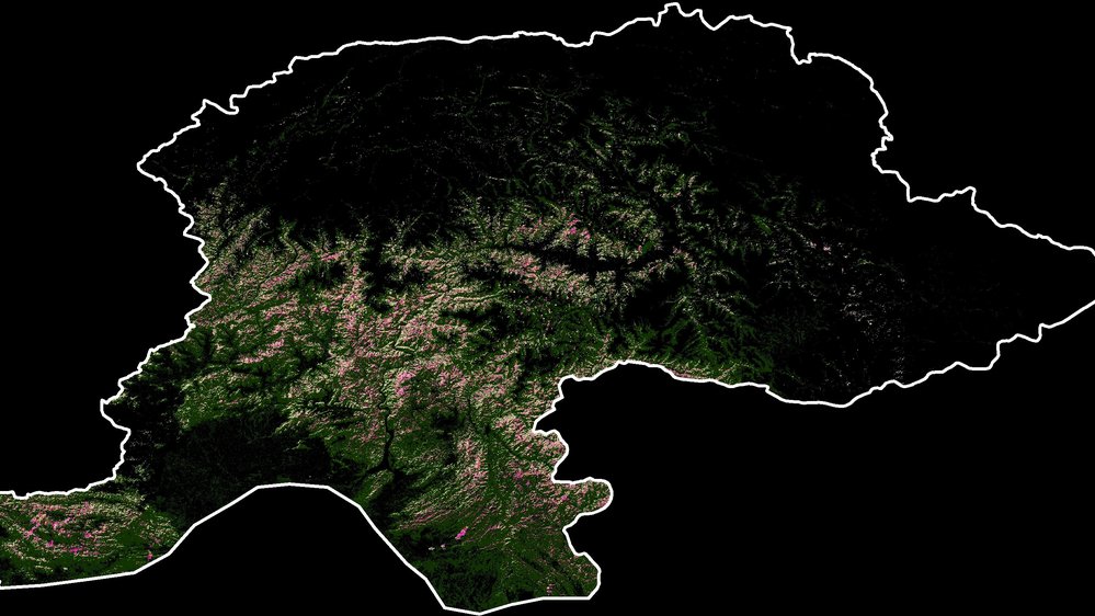
Multi-temporal satellite monitoring of environmental hazards, forest degradation, terrain vulnerability, and slope kinematics for data-driven Disaster Risk Reduction (DRR) and climate resilience.
Hazards • DRR Analytics
2022 Flood Inundation
Inspect Figure
Pillar 02 // Hydrology
Water & Basin Hydrology
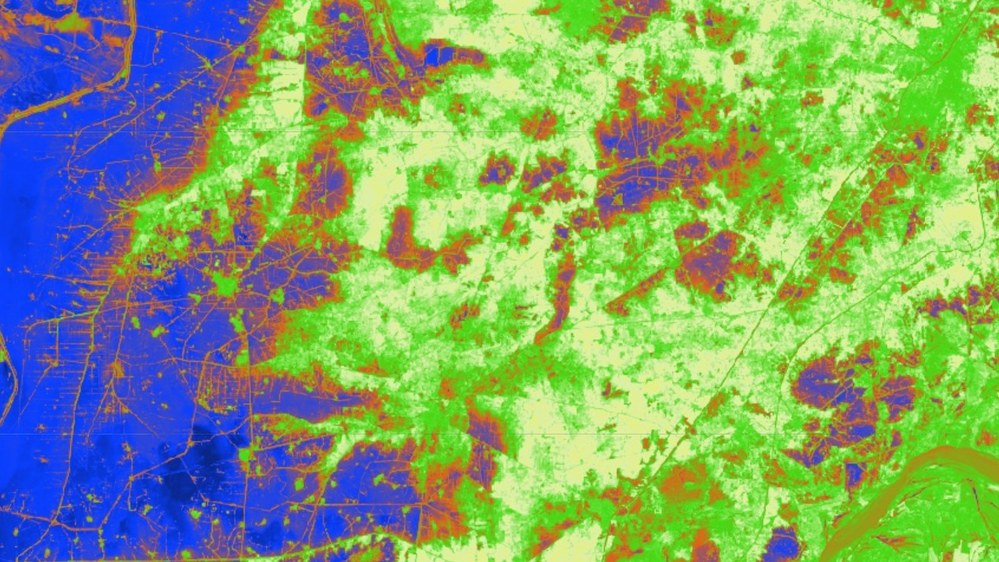
High-resolution satellite mapping and spatial assessment of agricultural cropland inundated during the historic 2022 Indus Basin mega-floods, quantifying submerged acreage and hydrological drainage dynamics.
2022 Flood • Cropland Inundation
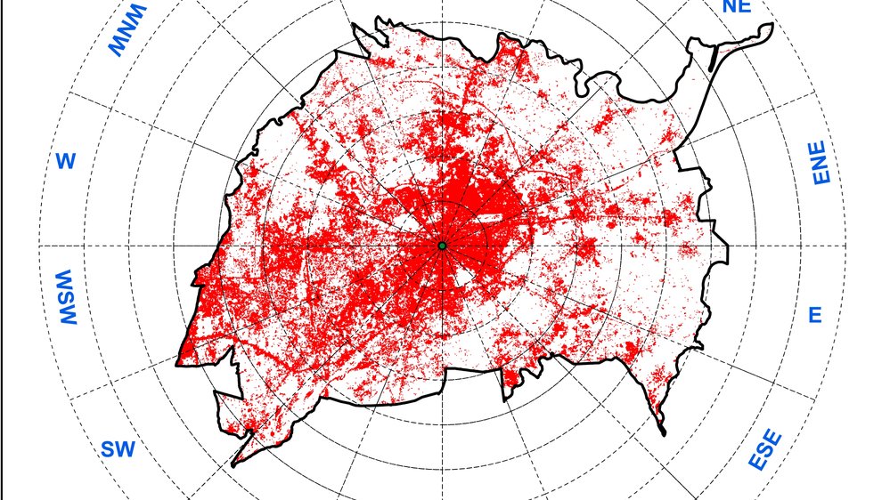
1/4 • 1990 Built-Up
Inspect
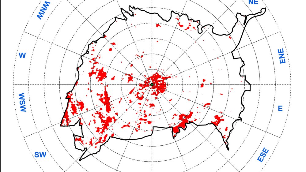
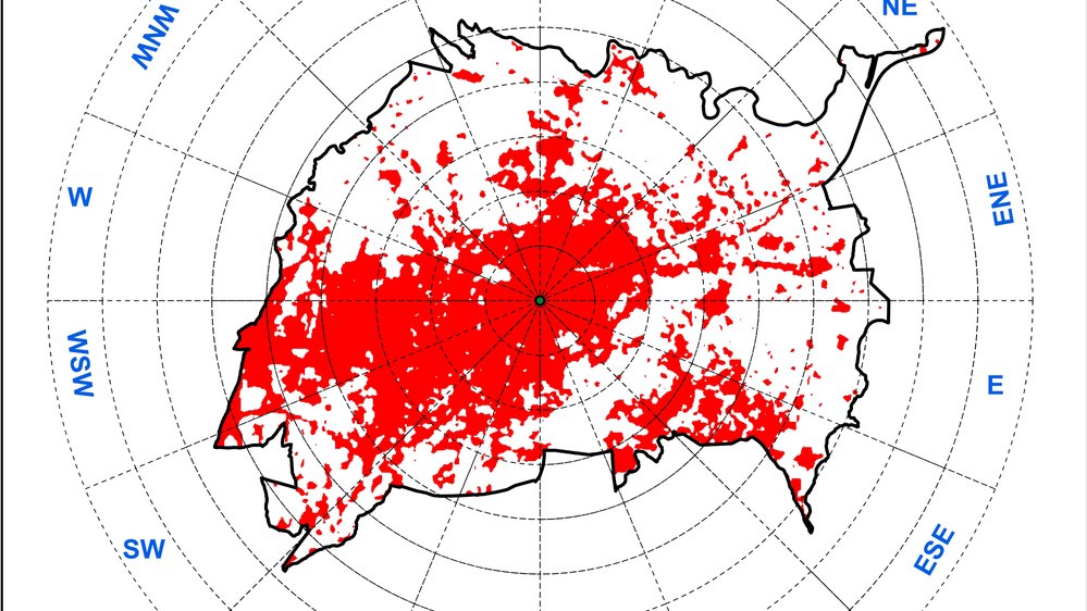
TIMELINE TRANSITION
19902020
Pillar 03 // Microclimate
Climate & Urban Heat (LST)
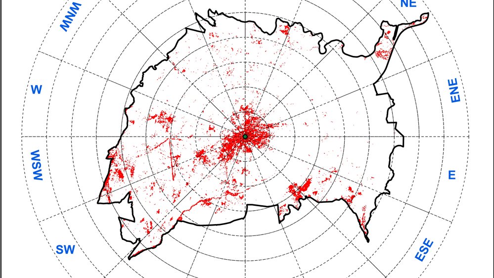
Drag the timeline bar to inspect the 30-year empirical coupling: rapid built-up expansion (1990–2020) directly driving extreme thermal anomalies ($LST > 28^\circ\text{C}$) across radial buffer zones.
4-Stage Timeline
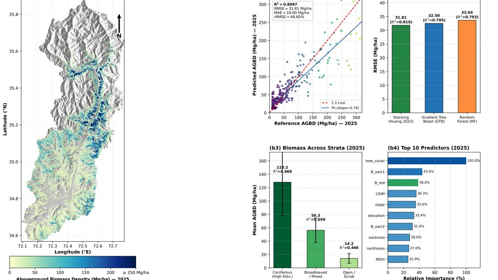
AGB Density Model
Inspect Figure
Pillar 04 // Ecology
Carbon, Agro & Ecosystems
Empirical Above-Ground Biomass (AGB) auditing, Sentinel-2 vegetation health (NDVI/EVI), precision agriculture crop monitoring, and forest conservation carbon stock verification.
Carbon Stocking
// 03. Global Partnerships
Collaborations.
Three Dedicated Collaboration Tracks
We partner with academic research laboratories, international development organizations, and enterprise consultancies to translate complex Earth observation data into verifiable decisions.
Scientists & Academics[TRACK 01]
Working with scientists & research groups
We collaborate with researchers worldwide—including joint research in China and the USA—co-authoring 12 peer-reviewed papers in high-impact Scopus/WoS journals. We develop custom GEE machine learning pipelines, validate spatiotemporal indices, and model snowmelt ablation rates.
Key Engagements:
✓China-Pakistan Advanced Remote Sensing Analytics
✓USA International Snowmelt & Thermal Hydrology Study
✓12 Scopus / Web of Science (Q1/Q2) Journal Papers
Dr. Mudassir Khan was selected by the Government of Japan (Ministry of Foreign Affairs) as a JENESYS International Fellow in Tokyo for disaster resilience and sustainability. He also advised a World Bank Consultant on cryospheric snow cover monitoring across the HKH.
Key Engagements:
✓Japan Ministry of Foreign Affairs (JENESYS Fellow Tokyo)
✓World Bank Consultant Advisory: Snow Cover Variations
We provide engineering and environmental consultancies with turnkey spatial AI workflows: Sentinel-1 InSAR millimeter subsidence auditing, kinematic slope stability zonation for highways and dams, and empirical AGB forest carbon stock modeling for ESG compliance.
Six specialized Earth observation, spatial data science, machine learning, and geohazard modeling capabilities.
AI and data science
Applying machine learning and spatial statistics (Random Forest, XGBoost, Support Vector Machines, ANN, and cellular automata WE–CA/FLUS) to uncover hidden patterns and forecast environmental trajectories.
Random ForestXGBoostSpatial ML
Earth observation & InSAR
Converting multi-sensor spaceborne imagery (Sentinel-1 SAR interferometry, Landsat 8–9 Thermal, Sentinel-2 MSI, MODIS, and UAV photogrammetry) into actionable ground telemetry.
Sentinel-1 InSARLandsat 8-9UAV Drone
Visualization & storytelling
Designing clear, publication-grade cartographic layouts, interactive web map dashboards, and visual narratives that help decision-makers comprehend complex planetary trends.
Publication MapsWebGIS DashboardsQ1 Figures
Geospatial AI & hazard modeling
Executing slope stability kinematics, landslide susceptibility zonation, 3D DEM morphometry, fault line buffer exposure, and terrain hazard mitigation planning.
Slope StabilityDEM MorphometryGeohazards
Cloud data infrastructure
Architecting scalable petabyte-scale cloud infrastructure with Google Earth Engine (GEE), Python geospatial toolchains (GeoPandas, Rasterio), and PostGIS relational spatial databases.
GEE Cloud EnginePython GeoStackPostGIS
Mentorship & 1-on-1 coaching
Delivering structured 3-tier masterclasses in QGIS, ArcGIS Pro, and advanced GeoAI for graduate researchers, university scholars, and geospatial industry engineers worldwide.
1-on-1 Mentorship3 TiersGlobal Scholars
GIS Academy & 1-on-1 Mentorship
Master GIS, Satellite Remote Sensing & GeoAI
Learn directly from Dr. Mudassir Khan, Ph.D. Personalized 1-on-1 coaching, hands-on lab projects with real satellite datasets, and research thesis mentorship across three structured tiers.
1-on-1 Personalized Mentorship
Real Multi-Sensor Datasets
Flexible Weekend & Evening Slots
Certificate of Completion
Tier 1 • Beginner
ArcGIS Pro / QGIS
🗺️
Basic GIS & Cartography Fundamentals
Ideal for undergraduates, civil engineers, ecologists, geologists, and beginners taking their first steps in spatial science.
Core Curriculum:
Foundations of GIS & Spatial Thinking (Vector vs Raster)
Coordinate Reference Systems (CRS) & Projections (WGS84, UTM)
Georeferencing Historical Maps, Scans & Base Layers
Professional Cartography: Publication-Grade Layouts & Symbology
Field GPS Data Integration & Google Earth Pro Workflows
Capstone Project:Design a publication-ready multi-layer thematic cartographic map with scale bars, legends, and study area inset for an academic report.
Capstone Project:Execute a complete 20-year LULC and Urban Heat Island (UHI) spatiotemporal change analysis with confusion matrix validation and thesis-ready charts.
Capstone Project:Build an automated Google Earth Engine GeoAI pipeline for above-ground biomass estimation or flood hazard forecasting with reproducible cloud code.
Whether you need emergency thesis data analysis support, custom Python GEE scripts, or corporate training for your engineering team, Dr. Mudassir Khan delivers customized private 1-on-1 coaching packages.
12 Verified ArticlesScopus & Web of Science (Q1/Q2)
Peer-Reviewed Journal Publications (12).
High-impact research articles published in Nature Scientific Reports, Spatial Information Research (Springer), Heliyon, Sustainability, GeoJournal, and Environment, Development and Sustainability spanning satellite remote sensing, GeoAI, and environmental modeling.
Spatial Information Research (Springer)
Latest 2026 Publication
Emerging glacial lake hazards under climate change in Upper Swat, Pakistan
Qasim, M., Nafees, K., & Khan, M. (2026). Spatial Information Research.
Multi-decadal satellite cryosphere monitoring (Landsat 1988–2020) and Support Vector Machine (SVM) spatial machine learning classifying 66 newly emerged glacial lakes, evaluating rapid permanent snowpack retreat and GLOF risk zones across Upper Swat.
Earth Systems and EnvironmentAccepted / 2026
Modeling Land Surface Temperature Response to Forest Degradation and Restoration in the Himalaya Region
Khan, M. et al. (Accepted for Publication in Earth Systems and Environment).
Environmental Geotechnics2026
Biochar-based stabilised dredged sediment substrates: strength and vegetation performance
Ullah, S., Ni, J., Qasim, M., & Khan, M. (2026). Environmental Geotechnics.
Scientific Reports (Nature)2025
Carbon dynamics with stand structure and species diversity in the Hindu Kush Himalaya ranges of Pakistan
Ahmad, A., Khan, M., Ahmad, T., Ahmad, S., Ullah, S., & Farooqi, A. (2025). Scientific Reports, 15(1), 35440.
Environmental Earth Sciences2025
Geochemical controls on arsenic release in reducing aquifers: role of methane and groundwater quality in shale gas bearing zones of Sindh
Soomro, M. H., Masood, N., Khan, M., & Farooqi, A. (2025). Environmental Earth Sciences, 84(20), 577.
Environment, Development and Sustainability (Springer)2025
Evaluating the impact of urbanization patterns on LST and UHI effect in Afghanistan’s Cities: a machine learning approach for sustainable urban planning
Ullah, S., Khan, M., & Qiao, X. (2025). Environment, Development and Sustainability, 1–42.
Heliyon (Cell Press)2024
Predicting land use dynamics, surface temperature and urban thermal field variance index in mild cold climate urban area of Pakistan
Khan, M., Qasim, M., Ahmad, A., Tahir, A. A., & Farooqi, A. (2024). Heliyon, 10(19).
GeoJournal (Springer)2024
Examining the impact of land use and land cover changes on land surface temperature in Herat city using machine learning algorithms
Ullah, S., Khan, M., & Qiao, X. (2024). GeoJournal, 89(5), 225.
Heliyon (Cell Press)2023
Machine learning-based assessment and simulation of land use modification effects on seasonal and annual land surface temperature variations
Khan, M., Qasim, M., Tahir, A. A., & Farooqi, A. (2023). Heliyon, 9(12).
Remote Sensing Applications: Society and Environment (Elsevier)2023
Spatial and temporal analyses of land use changes with special focus on seasonal variation in snow cover in district Chitral; a Hindu Kush mountain region of Pakistan
Qasim, M., Khan, M., & Rashid, W. (2023). Remote Sensing Applications: Society and Environment, 29, 100902.
Environmental Monitoring and Assessment (Springer)2022
Trends and projections of land use land cover and land surface temperature using an integrated weighted evidence-cellular automata (WE-CA) model
Khan, M., Tahir, A. A., Ullah, S., Khan, R., Ahmad, K., Shahid, S. U., & Nazir, A. (2022). Environmental Monitoring and Assessment, 194(2), 120.
Sustainability (MDPI)2019
Remote sensing-based quantification of the relationships between land use land cover changes and surface temperature over the lower Himalayan region
Ullah, S., Tahir, A. A., Akbar, T. A., Hassan, Q. K., Dewan, A., Khan, A. J., & Khan, M. (2019). Sustainability, 11(19), 5492.
// 05. Client Testimonials & Trust
Client Reviews & Industry Trust.
Endorsements and verified feedback from academic researchers, World Bank consultants, and international GIS partners.
★ ★ ★ ★ ★
5.0 / 5.0 Rating
5+ Verified Endorsements
Scroll horizontally or use arrows to view all client reviewsShowing 5 Client Reviews
AI & SENSOR INSIGHT // PLANETARY ATLAS
Earth Atlas: planetary data & geospatial data science insight.
Directly explore the spatial footprint of Dr. Mudassir Khan's peer-reviewed investigations across Pakistan, the Hindu Kush Himalayas, and the Indus Basin. Inspect geospatial hazard study sites, toggle satellite and topographic layers, or download standardized GIS spatial datasets.
10Study Sites
4 MajorRiver Basins
6 SensorsLandsat / Sentinel
Cursor: 31.5000° N, 71.8000° E|Zoom: 6.0
CRS: WGS 84 (EPSG:4326)|UTM Zone 42N/43N
Study Site Inspector
SITE #1 OF 10
// 08. Inquiries & Scientific Partnerships
Connect & Contact With Us.
Available for post-doctoral research collaborations, academic appointments, consultancy in geospatial data science & remote sensing, and guest lecturing.
Location
Islamabad, Pakistan [WGS84: 33.7294° N, 73.0931° E] • Global Remote